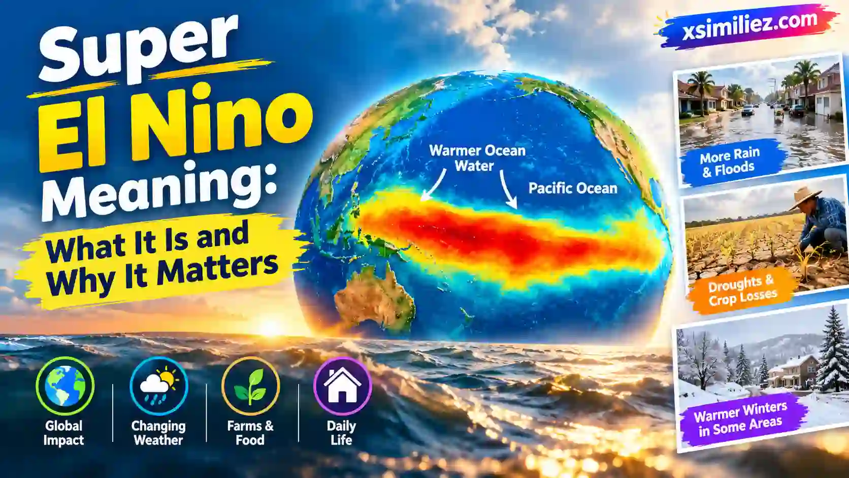
Super el nino meaning is simple: it is a nickname for a very strong El Niño, a burst of extra-warm ocean water in the Pacific that can change weather around the world. Scientists don’t use it as an official name. People use it when the warm water runs far above normal.
You may have seen these words in the news lately. That is probably why you are here. Many people want to know if it is real science, if it is scary, and what it means for winter, farms, and daily life.
In this guide, you will learn what the term means, how it works, where the name came from, and how past events changed the weather. You will also get easy tips to help you get ready.
Super El Nino Meaning: The Quick Answer
A “super El Niño” is an unofficial label for a very strong El Niño event. In science terms, it usually means the water in a key part of the Pacific Ocean stays at least 2.0°C (about 3.6°F) warmer than normal.
That may not sound like much. But the ocean is huge. When a big area of it holds that much extra heat, it changes wind, clouds, and rain far away.
Here is a short way to remember it:
El Niño = warm Pacific water that changes weather.
Super El Niño = a very strong version of that.
It is a nickname, not a formal category. The World Meteorological Organization has said it does not use the term because it is not part of standard operational labels. The WMO does not use the phrase “super El Niño” because it is not a standardized operational classification. So when you see the words in a headline, read them as “very strong El Niño.”
What Is El Niño? The Basics in Plain English
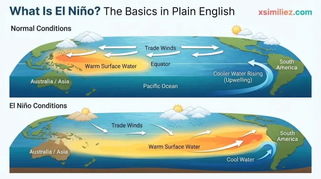
To understand the super version, you first need to know the normal one. El Niño is a natural climate pattern. It happens in the tropical Pacific Ocean, along the equator, and it comes back every few years.
On a normal day, strong winds called trade winds blow from east to west across the Pacific. They push warm surface water toward Asia and Australia. Cooler water then rises up near South America to take its place. Think of it like a giant conveyor belt.
During El Niño, those winds get weaker. The warm water slides back east toward South America. Now the middle and eastern Pacific hold a lot more heat than usual. Warm water makes more clouds and storms. Those storms change the jet stream, which is a fast river of air high above Earth. When the jet stream moves, weather moves with it.
El Niño is one part of a bigger cycle. Scientists call the full cycle ENSO, short for El Niño–Southern Oscillation. It has three phases: El Niño (warm), La Niña (cool), and neutral (in the middle). El Niño usually lasts about nine to twelve months. It often peaks in late fall or winter, which is why its biggest effects show up in the colder months.
How Scientists Decide an El Niño Is “Super”
Scientists don’t guess. They measure. They watch the sea surface temperature in a zone called Niño 3.4, which sits in the central Pacific. Then they compare it to the long-term normal.
Here is how the strength levels usually work:
| Strength Level | Warmer Than Normal (°C) | Warmer Than Normal (°F) | Plain-English Meaning |
| Weak | 0.5 to 0.9 | 0.9 to 1.6 | Small changes, hard to notice |
| Moderate | 1.0 to 1.4 | 1.8 to 2.5 | Clear effects in some places |
| Strong | 1.5 to 1.9 | 2.7 to 3.4 | Big effects in many places |
| Very Strong (“Super”) | 2.0 or higher | 3.6 or higher | Major, worldwide effects |
Two more details help here. First, the warm water has to last. One hot week is not enough. Scientists look for several months in a row. Second, the ocean and air must act together. The winds and clouds above the water must also show the El Niño pattern.
So the super el nino meaning is really about two things: how warm the water gets and how long it stays that way. The stronger and longer it is, the bigger the chance of wild weather.
Also keep in mind that “very strong” is a range. Some events barely cross the line. Others blow far past it. That is why one super El Niño can feel very different from another.
Where the Name El Niño Came From
The name has a sweet and surprising story. In Spanish, “El Niño” means “the boy.” Long ago, fishermen along the coast of Peru and Ecuador noticed something odd. Around Christmas time, the sea got warmer and the usual fish left the area.
They named it after the Christ child, because it showed up near December 25. At first, it was just a local fishing term for a yearly warm spell. Later, scientists learned that in some years the warm water was much stronger and lasted much longer. Those years brought floods, dead fish, and hungry seabirds.
Over time, the name grew from a local saying to a world-famous science term. The “super” part is much newer. It is a media and public nickname, and it is not from a science rulebook. It caught on because it is short, easy to remember, and tells people right away that this one is big.
How a Super El Niño Changes Weather Around the World
Here is why a warm patch of ocean matters so much: heat moves energy into the air, and air carries weather everywhere. When the Pacific changes, the jet stream shifts. Storms that normally go one way may go another.
A very strong El Niño often brings some common patterns. Places in the tropical Pacific and parts of South America get extra rain. Southern parts of the United States often get wetter winters. Northern parts of the United States and Canada often get warmer ones. Meanwhile, some other areas turn dry.
Here are some regions that often feel the effects:
- Peru and Ecuador: heavy rain and flooding
- Indonesia and Australia: drought and higher fire risk
- Southern Africa: dry spells that can hurt crops
- South Asia: a weaker monsoon in some years
- Southern U.S.: wetter and stormier winters
No two events are the same. The weather is messy, and El Niño is only one piece. Think of it as loading the dice. It doesn’t decide every roll, but it changes your odds. That is why forecasters talk about chances and trends and don’t make promises for one town in one day.
Famous Super El Niño Events From the Past
We can learn a lot from history. Three past events are often called “super” El Niños. They are 1982–83, 1997–98, and 2015–16.
| Event | What Happened | Why People Remember It |
| 1982–83 | Heavy rain in Peru and Ecuador, drought in Australia | It caught many scientists by surprise |
| 1997–98 | Floods in the U.S. West, fires in Indonesia | It led to huge growth in forecasting |
| 2015–16 | Record global heat, widespread coral bleaching | It helped push 2016 to a record-warm year |
| 2026 | Very strong event developing now | Forecasters say it could rank among the strongest ever |
The 1982–83 event was a wake-up call. Few people saw it coming, and the damage was large. Because of it, governments put more money into ocean buoys and satellites so scientists could spot the next one sooner.
The 1997–98 event tested those new tools. Forecasters gave earlier warnings this time, and many communities had time to prepare. That saved money and helped protect people.
The 2015–16 event showed another side. It arrived on top of a warming planet, and global temperatures hit new highs. This is a key idea. El Niño is natural, but it adds heat on top of long-term warming. That is why very strong events can push records higher.
Real-Life Examples: What a Super El Niño Feels Like
Numbers are useful, but daily life is where people feel weather. Here are a few simple examples of how a super El Niño can touch normal lives.
Imagine a farmer in Australia. When El Niño gets strong, rain often drops. Fields dry out. Wheat and other crops can suffer. Farmers may plant less or change what they grow. When harvests shrink, food prices can rise, sometimes in places far from the farm.
Now think about a fisher in Peru. Warm water pushes cold-loving fish away. Boats come back with small catches. Since Peru is a top fishing nation, this can affect animal feed and food markets worldwide.
Picture a family in Southern California. In a strong El Niño winter, storms can roll in one after another. That can bring flooding and mudslides, especially on hills burned by past wildfires. People there may need to plan for road closures and clean up their storm drains.
Finally, think of a homeowner in the northern U.S. A strong El Niño often means a milder winter. That can lower heating bills, but it can also mean less snow for skiing towns and for the melting snowpack that many places use for water in summer.
Each story is different. Yet they share one thread: a change in one ocean shows up in fields, boats, roofs, and wallets.
Super El Nino Meaning in the News Right Now
The topic is hot in 2026 because a strong event is actually happening. Here is what the latest reports say.
NOAA’s Climate Prediction Center has an El Niño Advisory in place. That means El Niño is here now, and it is not just a forecast. The agency says El Niño is strengthening, with a greater than 90% chance of a very strong event during the fall and winter of 2026–27.
Other groups see the same trend. The International Research Institute at Columbia University reported that a key Pacific temperature reading reached about 3.0°C above normal in mid-September, and all 22 models it tracks expect the event to stay very strong through winter. That is well past the 2.0°C line for “very strong.”
Some news outlets are going even further. CNN reported that this event could become a “super” El Niño and has a nearly 70% chance of becoming the strongest on record by the end of the year. Keep in mind that a forecast is a chance, not a sure thing. Scientists say there is still some uncertainty about exactly how high the peak will go.
What might this mean for the United States? NOAA’s outlook shows the best odds of above-normal rain over the Gulf States and parts of the Southeast and Mid-Atlantic. The northern states are more likely to see warmer-than-normal weather. Strong El Niño summers also tend to calm the Atlantic hurricane season, though the Pacific can get busier.
NOAA usually updates its El Niño outlook once a month, on the second Thursday. If you want the freshest facts, that is the page to check.
Common Mistakes and Myths About Super El Niño
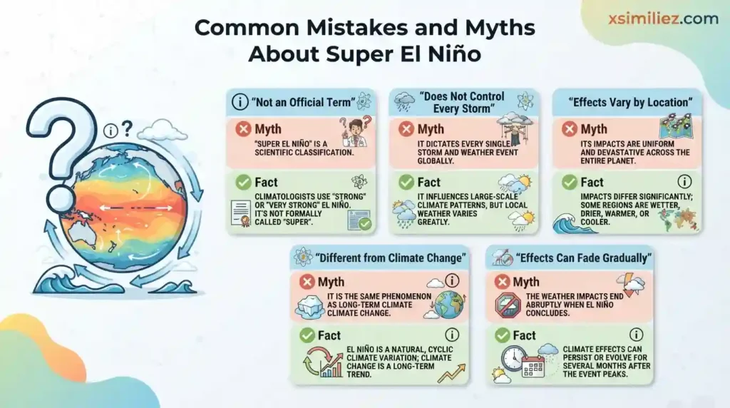
Big topics attract big misunderstandings. Here are the most common ones.
Myth 1: “Super El Niño” is an official scientific category. It is not. The official language is “very strong El Niño.” The word “super” is a nickname that helps people remember how big it is.
Myth 2: A super El Niño causes every storm and heat wave. It doesn’t. It changes the odds, but many other things shape weather too. Local patterns, other ocean cycles, and plain luck all play a part.
Myth 3: It affects every place in the same way. This is not true. Some areas get flooded while others get drought. Even in the same country, one state may be soaked and another dry.
Myth 4: El Niño and climate change are the same thing. They are different. El Niño is a natural cycle that has been around for a very long time. Climate change is a long-term warming trend. The two can stack, which can make hot years hotter. But one doesn’t equal the other. Scientists are still studying If climate change changes how often or how strong El Niño events are, and the WMO has said it has not seen clear proof that it does.
Myth 5: The event ends the moment the winter does. In fact, El Niño can fade slowly through spring. Some effects can linger for months after the peak.
Myth 6: You should panic. You shouldn’t. Forecasts exist to help you prepare. A warning is a gift of time.
Simple Tips to Get Ready for a Super El Niño Winter
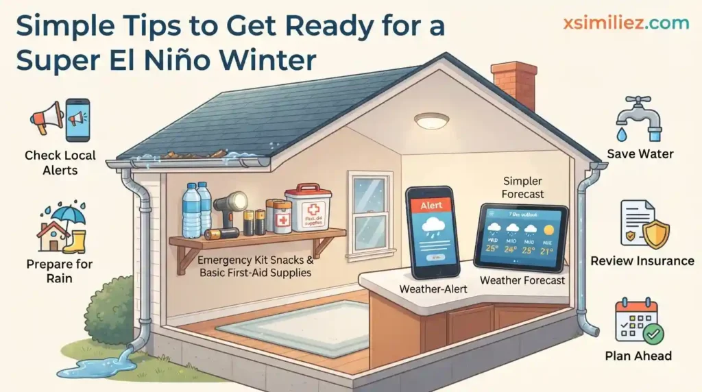
You can’t control the ocean, but you can control how ready you are. These tips are simple and low-cost.
If you live where more rain is likely, start with your home. Clean your gutters and drains so water can flow. Check your roof for leaks. Know your area’s flood risk, and learn where to go if you have to leave. Keep a small emergency kit with water, snacks, a flashlight, batteries, and any medicine your family needs.
If you live where a drier or warmer winter is expected, think about water use and fire safety. Trim dry brush near your home. Follow local rules on watering. Keep an eye on air quality in fire-prone places.
If you run a farm or small business, look at your supply chain. Ask what happens if a key crop or product gets more expensive. It can help to have a backup supplier. Some farmers also talk with local extension offices about what to plant.
For everyone, here are three good habits:
- Check the weather forecast from a trusted source such as the National Weather Service.
- Sign up for local emergency alerts.
- Ask your insurance company what your policy covers, since many plans don’t cover floods.
Small steps add up. Being a little ready is far better than being surprised.
FAQs
1. What is the meaning of super El Niño?
It is a nickname for a very strong El Niño. That means the water in the central Pacific is at least 2.0°C (3.6°F) warmer than normal for a long stretch. The extra heat can shift weather patterns around the globe.
2. Is a super El Niño an official term?
No. Scientists at groups like NOAA use the term “very strong El Niño.” The word “super” is a popular nickname used in the news and online.
3. How often does a super El Niño happen?
They are rare. Only a few have been recorded in the modern era, and the most talked-about ones were in 1982–83, 1997–98, and 2015–16. That works out to roughly one every 15 to 20 years, though the pattern isn’t exact.
4. Is there a super El Niño in 2026?
A very strong El Niño is developing right now. NOAA has an El Niño Advisory in place and gives a high chance that it will reach very strong levels this fall and winter. If it ends up being the strongest on record is still uncertain.
5. Does a super El Niño mean more hurricanes?
Not in the Atlantic. Strong El Niño years tend to make Atlantic hurricanes less likely, because the extra wind shear tears storms apart. The central and eastern Pacific can see more storms instead.
6. Can a super El Niño make global temperatures hit new records?
Yes, it can. El Niño releases stored ocean heat into the air, and that often raises global temperatures. When this happens on top of long-term warming, record-warm years become more likely.
Conclusion
So, what is the super el nino meaning in one line? It is a handy nickname for a very strong El Niño, a big, long-lasting patch of warm Pacific water that can change weather across the planet. It isn’t an official science label, but it points to a real and measurable event.
The main things to remember are these. El Niño is natural. A “super” one is unusually strong. Its effects vary by place, with floods in some areas, drought in others, and warmer conditions in many. And it can push global heat higher, especially now, when the planet is already warming.
Your best move is to stay calm and stay informed. Follow NOAA and your local weather service, check your home and your emergency kit, and make a simple plan. Understanding the super el nino meaning is the first step. Being ready is the second, and it is the one that keeps your family safe.

Hi, I’m Harper Blake, and I write for Xsimiliez.com. I enjoy sharing clear and friendly simile examples that students and beginners can understand easily. My goal is to make English learning simple and enjoyable.